Mynd:Water End Swallow Hole - geograph.org.uk - 990487.jpg
Jump to navigation
Jump to search


Það er engin hærri upplausn til.
Water_End_Swallow_Hole_-_geograph.org.uk_-_990487.jpg (640 × 480 mynddílar, skráarstærð: 126 KB, MIME-gerð: image/jpeg)
Lýsing
| Lýsing |
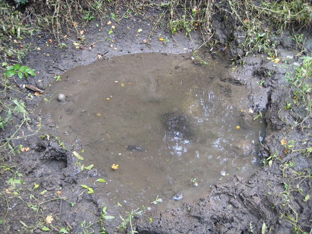
English: Water End Swallow Hole Water End Swallow Holes are the only major sinkholes in chalk which are a permanent feature of the landscape. The site covers a group of more than 15 sinkholes where two streams drain from the London Clay and sink very close to the boundary of the outcrop of the chalk. This is one of the holes. The water is flowing in from the top right corner and exits underground at the middle right. The whole site is an SSSI. |
| Dagsetning | |
| Uppruni | From geograph.org.uk |
| Höfundarréttarhafi | Nigel Cox |
| Tilvísun höfundarréttar (required by the license) | Nigel Cox / Water End Swallow Hole / |
| Camera location | | View this and other nearby images on: OpenStreetMap |
|---|
_heading:45.00&language=is)
| Object location | | View this and other nearby images on: OpenStreetMap |
|---|
_heading:45.00&language=is)
Leyfisupplýsingar:

|
This image was taken from the Geograph project collection. See this photograph's page on the Geograph website for the photographer's contact details. The copyright on this image is owned by Nigel Cox and is licensed for reuse under the Creative Commons Attribution-ShareAlike 2.0 license.
|
This file is licensed under the Creative Commons Attribution-Share Alike 2.0 Generic license.
Tilvísun höfundarréttar: Nigel Cox
- Þér er frjálst:
- að deila – að afrita, deila og yfirfæra verkið
- að blanda – að breyta verkinu
- Undir eftirfarandi skilmálum:
- tilvísun höfundarréttar – Þú verður að tilgreina viðurkenningu á höfundarréttindum, gefa upp tengil á notkunarleyfið og gefa til kynna ef breytingar hafa verið gerðar. Þú getur gert þetta á einhvern ásættanlegan máta, en ekki á nokkurn þann hátt sem bendi til þess að leyfisveitandinn styðji þig eða notkun þína á verkinu.
- Deila eins – Ef þú breytir, yfirfærir eða byggir á þessu efni, þá mátt þú eingöngu dreifa því verki með sama eða svipuðu leyfi og upprunalega verkið er með.
Breytingaskrá skjals
Smelltu á dagsetningu eða tímasetningu til að sjá hvernig hún leit þá út.
| Dagsetning/Tími | Smámynd | Víddir | Notandi | Athugasemd | |
|---|---|---|---|---|---|
| núverandi | 23. febrúar 2011 kl. 05:42 | | 640 × 480 (126 KB) | GeographBot | == {{int:filedesc}} == {{Information |description={{en|1=Water End Swallow Hole Water End Swallow Holes are the only major sinkholes in chalk which are a permanent feature of the landscape. The site covers a group of more than 15 sinkholes where two strea |
Skráartenglar
Eftirfarandi síða notar þessa skrá: